Dunn night lights from space
Night Light of Dunn (North Carolina) from space (United States) Src. Average luminocity for 10x10km area is 50.7143% and for 50x50km: 15.6267%.
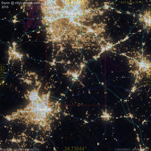
Analysis of Dunn night lights 2016
Square area 10x10 km:
 6.59%
6.59%90-99
7.33%80-89
8.24%70-79
7.14%60-69
7.88%50-59
8.79%40-49
9.16%30-39
14.1%20-29
17.03%10-19
13.19%0-9
0.55%Square area 50x50 km:
0.86%90-99
0.87%80-89
2.41%70-79
1.74%60-69
2.41%50-59
2%40-49
2.8%30-39
4.67%20-29
5.56%10-19
17.08%0-9
59.59%Clear (daylight) street map image can be seen on geolist.org.
Map coordinates:
35° 52' 40.9" North, 79° 18' 43.3" West
35° 18' 22.6" North, 78° 36' 32" West
34° 43' 49.6" North, 77° 54' 20.8" West
Some cities around Dunn sort by population:
• Fayetteville
37.3 km =23.2 mi,  220°
220°
• Fort Bragg
40.6 km =25.2 mi,  242°
242°
• Fuquay-Varina
35.4 km =22 mi,  330°
330°
• Clayton
40.7 km =25.3 mi,  19°
19°
• Spring Lake
36.5 km =22.7 mi,  245°
245°
• Smithfield
33.2 km =20.6 mi,  47°
47°
• Clinton
43 km =26.7 mi,  142°
142°
• Selma
39 km =24.2 mi, 48°
4464326 (p: 9,723)
Sources (retrieved 2019-11-25):
» Earth at Night: Flat Maps 2012, 2016