Knightdale night lights from space
Night Light of Knightdale (North Carolina) from space (United States) Src. Average luminocity for 10x10km area is 60.0297% and for 50x50km: 47.7184%.
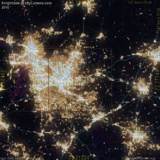
Analysis of Knightdale night lights 2016
Square area 10x10 km:
 3.67%
3.67%90-99
3.85%80-89
13.11%70-79
10.14%60-69
21.5%50-59
14.86%40-49
16.43%30-39
7.69%20-29
8.74%10-19
0%0-9
0%Square area 50x50 km:
6.38%90-99
6.54%80-89
9.16%70-79
9.14%60-69
10.78%50-59
7.57%40-49
6.91%30-39
7.61%20-29
7.63%10-19
8.84%0-9
19.43%Clear (daylight) street map image can be seen on geolist.org.
Map coordinates:
36° 21' 21.5" North, 79° 11' 1.3" West
35° 47' 15.5" North, 78° 28' 50" West
35° 12' 54.9" North, 77° 46' 38.8" West
Some cities around Knightdale sort by population:
• Raleigh
14.4 km =8.9 mi,  263°
263°
• West Raleigh
16.5 km =10.3 mi,  269°
269°
• Cary
27.1 km =16.8 mi, 270°
• Wake Forest
21.5 km =13.4 mi,  352°
352°
• Garner
14.7 km =9.1 mi,  234°
234°
• Clayton
15.4 km =9.6 mi,  171°
171°
• Rolesville
15.2 km =9.4 mi,  7°
7°
• Wendell
10 km =6.2 mi,  94°
94°
4474527 (p: 14,256)
Sources (retrieved 2019-11-25):
» Earth at Night: Flat Maps 2012, 2016