Smithfield night lights from space
Night Light of Smithfield (North Carolina) from space (United States) Src. Average luminocity for 10x10km area is 55.7216% and for 50x50km: 24.4562%.
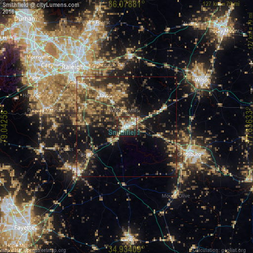
Analysis of Smithfield night lights 2016
Square area 10x10 km:
 10.99%
90-99
10.26%80-89
15.02%70-79
4.21%60-69
5.13%50-59
5.13%40-49
6.04%30-39
10.81%20-29
21.25%10-19
10.99%0-9
0.18%Square area 50x50 km:
1.44%90-99
1.63%80-89
3.9%70-79
4.11%60-69
4.7%50-59
4.02%40-49
5.2%30-39
7.89%20-29
7.49%10-19
13.81%0-9
45.82%Clear (daylight) street map image can be seen on geolist.org.
Map coordinates:
36° 4' 43.7" North, 79° 2' 33.3" West
35° 30' 30.6" North, 78° 20' 22" West
34° 56' 2.7" North, 77° 38' 10.8" West
Some cities around Smithfield sort by population:
• Raleigh
39.9 km =24.8 mi,  317°
317°
• Goldsboro
34.3 km =21.3 mi,  113°
113°
• Garner
33.5 km =20.8 mi,  312°
312°
• Clayton
19 km =11.8 mi,  326°
326°
• Knightdale
33.6 km =20.9 mi,  337°
337°
• Dunn
33.2 km =20.6 mi,  227°
227°
• Selma
5.9 km =3.7 mi,  57°
57°
• Wendell
30.4 km =18.9 mi,  354°
354°
4492168 (p: 12,022)
Sources (retrieved 2019-11-25):
» Earth at Night: Flat Maps 2012, 2016