Schuyler night lights from space
Night Light of Schuyler (Nebraska) from space (United States) Src. Average luminocity for 10x10km area is 9.7687% and for 50x50km: 2.2887%.
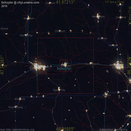
Analysis of Schuyler night lights 2016
Square area 10x10 km:
 0.34%
0.34%90-99
0.34%80-89
3.4%70-79
0.51%60-69
1.53%50-59
1.53%40-49
3.23%30-39
1.53%20-29
0.68%10-19
0.51%0-9
86.39%Square area 50x50 km:
0.23%90-99
0.31%80-89
0.49%70-79
0.19%60-69
0.27%50-59
0.21%40-49
0.28%30-39
0.44%20-29
0.55%10-19
1.63%0-9
95.41%Clear (daylight) street map image can be seen on geolist.org.
Map coordinates:
41° 58' 19.7" North, 97° 45' 45.4" West
41° 26' 50" North, 97° 3' 34.1" West
40° 55' 5" North, 96° 21' 22.9" West
Some cities around Schuyler sort by population:
• Fremont
46.8 km =29.1 mi,  91°
91°
• Norfolk
71.1 km =44.2 mi,  335°
335°
• Columbus
25.8 km =16 mi,  265°
265°
• Elkhorn
71.1 km =44.2 mi,  104°
104°
• Blair
78.6 km =48.8 mi,  82°
82°
• York
78.3 km =48.7 mi,  214°
214°
• Seward
60.2 km =37.4 mi,  183°
183°
• Gretna
76.5 km =47.5 mi,  116°
116°
5078641 (p: 6,171)
Sources (retrieved 2019-11-25):
» Earth at Night: Flat Maps 2012, 2016