Blair night lights from space
Night Light of Blair (Nebraska) from space (United States) Src. Average luminocity for 10x10km area is 27.8248% and for 50x50km: 6.3693%.
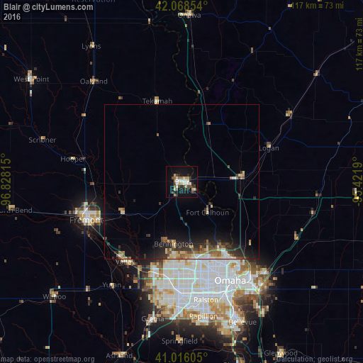
Analysis of Blair night lights 2016
Square area 10x10 km:
 4.42%
4.42%90-99
5.78%80-89
2.21%70-79
2.72%60-69
3.06%50-59
2.72%40-49
4.08%30-39
4.59%20-29
5.27%10-19
27.04%0-9
38.1%Square area 50x50 km:
0.67%90-99
0.8%80-89
0.94%70-79
0.47%60-69
0.9%50-59
0.96%40-49
0.99%30-39
1.26%20-29
2.24%10-19
4.16%0-9
86.61%Clear (daylight) street map image can be seen on geolist.org.
Map coordinates:
42° 4' 6.7" North, 96° 49' 41.3" West
41° 32' 40" North, 96° 7' 30.1" West
41° 0' 57.8" North, 95° 25' 18.8" West
Some cities around Blair sort by population:
• Omaha
35.5 km =22.1 mi,  154°
154°
• Council Bluffs
38.4 km =23.9 mi,  144°
144°
• Fremont
33.4 km =20.8 mi,  248°
248°
• Papillion
43.9 km =27.3 mi,  170°
170°
• La Vista
40.8 km =25.4 mi, 168°
• Chalco
40.1 km =24.9 mi,  183°
183°
• Elkhorn
30.1 km =18.7 mi,  197°
197°
• Ralston
38.3 km =23.8 mi, 169°
5064236 (p: 7,975)
Sources (retrieved 2019-11-25):
» Earth at Night: Flat Maps 2012, 2016