Elkhorn night lights from space
Night Light of Elkhorn (Nebraska) from space (United States) Src. Average luminocity for 10x10km area is 55.0812% and for 50x50km: 28.671%.
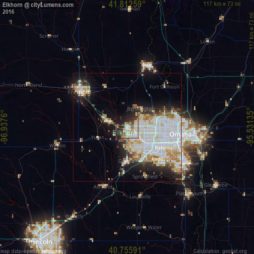
Analysis of Elkhorn night lights 2016
Square area 10x10 km:
 10.06%
90-99
15.1%80-89
9.09%70-79
4.38%60-69
6.66%50-59
5.19%40-49
6.01%30-39
10.88%20-29
14.77%10-19
15.58%0-9
2.27%Square area 50x50 km:
8.79%90-99
7.39%80-89
3.48%70-79
2.35%60-69
2.93%50-59
2.08%40-49
1.95%30-39
2.57%20-29
4.66%10-19
8.58%0-9
55.22%Clear (daylight) street map image can be seen on geolist.org.
Map coordinates:
41° 48' 45.3" North, 96° 56' 15.4" West
41° 17' 11" North, 96° 14' 4.1" West
40° 45' 21.3" North, 95° 31' 52.9" West
Some cities around Elkhorn sort by population:
• Omaha
24.8 km =15.4 mi,  97°
97°
• Fremont
27.4 km =17 mi,  306°
306°
• Papillion
21.8 km =13.5 mi,  132°
132°
• La Vista
20.5 km =12.7 mi,  123°
123°
• Chalco
13.4 km =8.3 mi,  148°
148°
• Blair
30.1 km =18.7 mi,  17°
17°
• Ralston
18.4 km =11.4 mi, 119°
• Gretna
16.2 km =10.1 mi,  181°
181°
5067545 (p: 8,251)
Sources (retrieved 2019-11-25):
» Earth at Night: Flat Maps 2012, 2016