Gretna night lights from space
Night Light of Gretna (Nebraska) from space (United States) Src. Average luminocity for 10x10km area is 29.6591% and for 50x50km: 26.1934%.
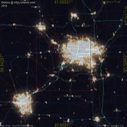
Analysis of Gretna night lights 2016
Square area 10x10 km:
 2.27%
2.27%90-99
3.08%80-89
5.36%70-79
3.41%60-69
5.03%50-59
3.41%40-49
3.41%30-39
6.17%20-29
14.29%10-19
26.62%0-9
26.95%Square area 50x50 km:
8.3%90-99
7.12%80-89
3.11%70-79
2.22%60-69
2.67%50-59
1.95%40-49
1.74%30-39
2.17%20-29
4.08%10-19
5.21%0-9
61.43%Clear (daylight) street map image can be seen on geolist.org.
Map coordinates:
41° 40' 5.6" North, 96° 56' 34.3" West
41° 8' 27" North, 96° 14' 23.1" West
40° 36' 33" North, 95° 32' 11.8" West
Some cities around Gretna sort by population:
• Omaha
28.1 km =17.5 mi,  62°
62°
• Bellevue
29.2 km =18.1 mi,  90°
90°
• Papillion
16.6 km =10.3 mi,  84°
84°
• La Vista
18.1 km =11.2 mi,  74°
74°
• Chalco
8.9 km =5.5 mi, 57°
• Elkhorn
16.2 km =10.1 mi,  1°
1°
• Plattsmouth
33.2 km =20.6 mi,  115°
115°
• Ralston
18 km =11.2 mi, 66°
5069480 (p: 5,046)
Sources (retrieved 2019-11-25):
» Earth at Night: Flat Maps 2012, 2016