Santa Ana night lights from space
Night Light of Santa Ana (California) from space (United States) Src. Average luminocity for 10x10km area is 98.3626% and for 50x50km: 63.6943%.
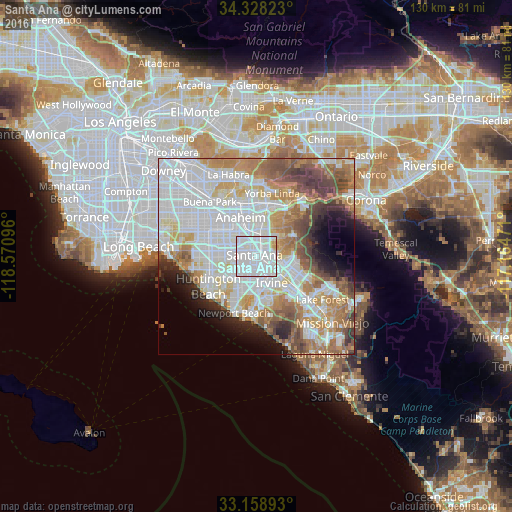
Analysis of Santa Ana night lights 2016
Square area 10x10 km:
 65.75%
90-99
29.3%80-89
2.75%70-79
2.2%60-69
0%50-59
0%40-49
0%30-39
0%20-29
0%10-19
0%0-9
0%Square area 50x50 km:
22.53%90-99
16.34%80-89
5.55%70-79
7.08%60-69
9.6%50-59
6.32%40-49
5.7%30-39
3.53%20-29
3.82%10-19
4.89%0-9
14.64%Clear (daylight) street map image can be seen on geolist.org.
Map coordinates:
34° 19' 41.6" North, 118° 34' 15.5" West
33° 44' 44.1" North, 117° 52' 4.2" West
33° 9' 32.1" North, 117° 9' 53" West
Some cities around Santa Ana sort by population:
• Anaheim
10.9 km =6.8 mi,  336°
336°
• Irvine
9.4 km =5.8 mi,  153°
153°
• Garden Grove
7.5 km =4.7 mi,  294°
294°
• Orange
4.9 km =3 mi,  16°
16°
• Tustin
3.9 km =2.4 mi,  89°
89°
• Fountain Valley
8.9 km =5.5 mi,  242°
242°
• North Tustin
7.1 km =4.4 mi,  72°
72°
• Villa Park
9.2 km =5.7 mi,  33°
33°
5392900 (p: 335,400)
Sources (retrieved 2019-11-25):
» NASA, Earths city lights 1995
» NASA city lights 2003
» Earth at Night: Flat Maps 2012, 2016