Sandalfoot Cove night lights from space
Night Light of Sandalfoot Cove (Florida) from space (United States) Src. Average luminocity for 10x10km area is 93.4905% and for 50x50km: 44.362%.
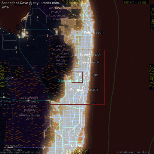
Analysis of Sandalfoot Cove night lights 2016
Square area 10x10 km:
 35.61%
90-99
39.39%80-89
14.58%70-79
8.9%60-69
1.33%50-59
0.19%40-49
0%30-39
0%20-29
0%10-19
0%0-9
0%Square area 50x50 km:
20.32%90-99
12.91%80-89
2.81%70-79
1.67%60-69
2.75%50-59
2.58%40-49
2.72%30-39
3.07%20-29
4.44%10-19
6.5%0-9
40.22%Clear (daylight) street map image can be seen on geolist.org.
Map coordinates:
26° 58' 1.3" North, 80° 53' 24.1" West
26° 20' 19.1" North, 80° 11' 12.8" West
25° 42' 24.4" North, 79° 29' 1.6" West
Some cities around Sandalfoot Cove sort by population:
• Coral Springs
11.2 km =7 mi,  228°
228°
• Boca Raton
10.6 km =6.6 mi,  77°
77°
• Deerfield Beach
9 km =5.6 mi,  104°
104°
• Coconut Creek
9.7 km =6 mi,  175°
175°
• Margate
10.6 km =6.6 mi,  190°
190°
• Parkland
5.9 km =3.7 mi,  237°
237°
• Boca Del Mar
4.1 km =2.5 mi, 79°
• Pompano Beach Highlands
10.1 km =6.3 mi,  127°
127°
7260095 (p: 16,582)
Sources (retrieved 2019-11-25):
» Earth at Night: Flat Maps 2012, 2016