Pompano Beach Highlands night lights from space
Night Light of Pompano Beach Highlands (Florida) from space (United States) Src. Average luminocity for 10x10km area is 84.7103% and for 50x50km: 44.822%.
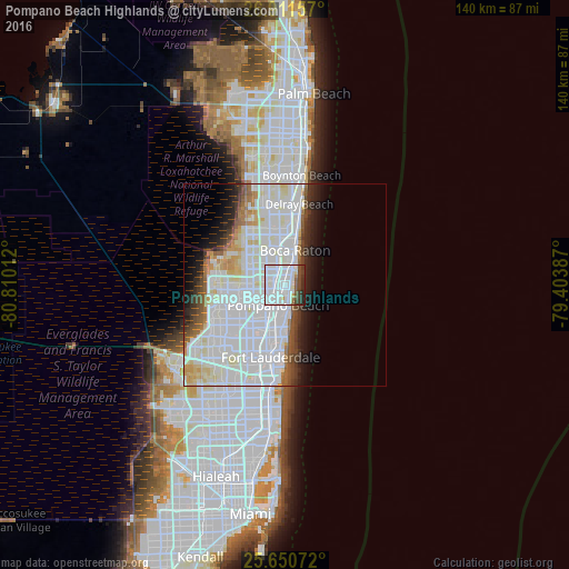
Analysis of Pompano Beach Highlands night lights 2016
Square area 10x10 km:
 47.62%
90-99
25%80-89
1.39%70-79
1.39%60-69
1.98%50-59
5.16%40-49
5.75%30-39
6.35%20-29
5.36%10-19
0%0-9
0%Square area 50x50 km:
21.29%90-99
13.1%80-89
3.12%70-79
1.93%60-69
2.4%50-59
2.32%40-49
2.43%30-39
2.57%20-29
3.62%10-19
5.23%0-9
42%Clear (daylight) street map image can be seen on geolist.org.
Map coordinates:
26° 54' 41.7" North, 80° 48' 36.4" West
26° 16' 58.3" North, 80° 6' 25.2" West
25° 39' 2.6" North, 79° 24' 13.9" West
Some cities around Pompano Beach Highlands sort by population:
• Boca Raton
8.8 km =5.5 mi,  15°
15°
• Deerfield Beach
4 km =2.5 mi,  10°
10°
• Coconut Creek
8 km =5 mi,  244°
244°
• Boca Del Mar
8 km =5 mi,  330°
330°
• Sandalfoot Cove
10.1 km =6.3 mi,  307°
307°
• Lighthouse Point
2.1 km =1.3 mi,  112°
112°
• North Andrews Gardens
10.8 km =6.7 mi,  200°
200°
• Lauderdale-by-the-Sea
10.2 km =6.3 mi,  174°
174°
4169018 (p: 7,192)
Sources (retrieved 2019-11-25):
» Earth at Night: Flat Maps 2012, 2016