Birdsboro night lights from space
Night Light of Birdsboro (Pennsylvania) from space (United States) Src. Average luminocity for 10x10km area is 25.5731% and for 50x50km: 25.9501%.
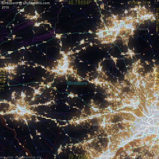
Analysis of Birdsboro night lights 2016
Square area 10x10 km:
 0.97%
0.97%90-99
1.3%80-89
3.57%70-79
3.9%60-69
3.73%50-59
4.87%40-49
8.77%30-39
3.41%20-29
5.03%10-19
31.82%0-9
32.63%Square area 50x50 km:
2.82%90-99
2.98%80-89
3.66%70-79
3.33%60-69
3.53%50-59
4.39%40-49
4.63%30-39
5.51%20-29
7.99%10-19
18.52%0-9
42.63%Clear (daylight) street map image can be seen on geolist.org.
Map coordinates:
40° 47' 56.2" North, 76° 30' 26" West
40° 15' 52.3" North, 75° 48' 14.7" West
39° 43' 33.2" North, 75° 6' 3.5" West
Some cities around Birdsboro sort by population:
• Reading
13.1 km =8.1 mi,  307°
307°
• Pottstown
13.3 km =8.3 mi,  99°
99°
• Limerick
24.2 km =15 mi, 98°
• Wyomissing
15.5 km =9.6 mi,  297°
297°
• Sanatoga
17.9 km =11.1 mi, 96°
• Chester Springs
24.7 km =15.3 mi,  139°
139°
• Blandon
20.9 km =13 mi,  340°
340°
• Shillington
14.5 km =9 mi,  289°
289°
5180620 (p: 5,159)
Sources (retrieved 2019-11-25):
» Earth at Night: Flat Maps 2012, 2016