Saint Anthony night lights from space
Night Light of Saint Anthony (Minnesota) from space (United States) Src. Average luminocity for 10x10km area is 95.8% and for 50x50km: 65.532%.
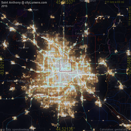
Analysis of Saint Anthony night lights 2016
Square area 10x10 km:
 55.56%
90-99
29.37%80-89
7.46%70-79
3.17%60-69
4.44%50-59
0%40-49
0%30-39
0%20-29
0%10-19
0%0-9
0%Square area 50x50 km:
18.44%90-99
15.5%80-89
7.64%70-79
9.16%60-69
12.22%50-59
8.37%40-49
5.73%30-39
3.63%20-29
5.39%10-19
6.09%0-9
7.83%Clear (daylight) street map image can be seen on geolist.org.
Map coordinates:
45° 30' 55.3" North, 93° 55' 16.1" West
45° 1' 13.9" North, 93° 13' 4.8" West
44° 31' 16.9" North, 92° 30' 53.6" West
Some cities around Saint Anthony sort by population:
• Minneapolis
5.8 km =3.6 mi,  218°
218°
• Roseville
5.1 km =3.2 mi,  108°
108°
• Fridley
8.1 km =5 mi,  333°
333°
• Shoreview
8.6 km =5.3 mi,  40°
40°
• New Brighton
5.2 km =3.2 mi,  14°
14°
• Columbia Heights
4.2 km =2.6 mi,  302°
302°
• Arden Hills
5.8 km =3.6 mi,  55°
55°
• Falcon Heights
5.2 km =3.2 mi,  128°
128°
5044290 (p: 8,226)
Sources (retrieved 2019-11-25):
» Earth at Night: Flat Maps 2012, 2016