Ruidoso night lights from space
Night Light of Ruidoso (New Mexico) from space (United States) Src. Average luminocity for 10x10km area is 24.6818% and for 50x50km: 1.8354%.
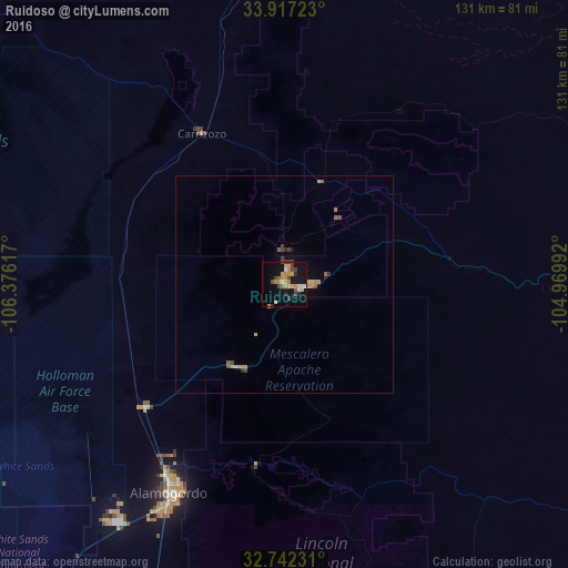
Analysis of Ruidoso night lights 2016
Square area 10x10 km:
 0.87%
0.87%90-99
2.62%80-89
4.37%70-79
7.34%60-69
2.62%50-59
2.45%40-49
5.07%30-39
1.92%20-29
2.45%10-19
25.87%0-9
44.41%Square area 50x50 km:
0.04%90-99
0.12%80-89
0.37%70-79
0.48%60-69
0.19%50-59
0.23%40-49
0.43%30-39
0.19%20-29
0.15%10-19
1.32%0-9
96.49%Clear (daylight) street map image can be seen on geolist.org.
Map coordinates:
33° 55' 2" North, 106° 22' 34.2" West
33° 19' 54.3" North, 105° 40' 22.9" West
32° 44' 32.3" North, 104° 58' 11.7" West
Some cities around Ruidoso sort by population:
• Las Cruces
153.3 km =95.3 mi,  222°
222°
• Roswell
106.8 km =66.4 mi,  86°
86°
• Alamogordo
55 km =34.2 mi,  209°
209°
• Carlsbad
168.7 km =104.8 mi,  126°
126°
• Chaparral
160 km =99.4 mi,  204°
204°
• Artesia
130.2 km =80.9 mi,  114°
114°
• Socorro
138.7 km =86.2 mi,  305°
305°
• Truth or Consequences
148.7 km =92.4 mi,  261°
261°
5488598 (p: 7,739)
Sources (retrieved 2019-11-25):
» Earth at Night: Flat Maps 2012, 2016