Chaparral night lights from space
Night Light of Chaparral (New Mexico) from space (United States) Src. Average luminocity for 10x10km area is 24.6958% and for 50x50km: 19.1107%.
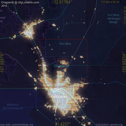
Analysis of Chaparral night lights 2016
Square area 10x10 km:
 0%
0%90-99
0%80-89
0.35%70-79
6.12%60-69
10.14%50-59
4.2%40-49
6.64%30-39
4.02%20-29
1.4%10-19
32.17%0-9
34.97%Square area 50x50 km:
2.26%90-99
2.37%80-89
2.11%70-79
6.3%60-69
3.68%50-59
2.01%40-49
2.42%30-39
1.83%20-29
4.59%10-19
7.84%0-9
64.59%Clear (daylight) street map image can be seen on geolist.org.
Map coordinates:
32° 37' 4.6" North, 107° 5' 19.6" West
32° 1' 25.5" North, 106° 23' 8.4" West
31° 25' 32.5" North, 105° 40' 57.1" West
Some cities around Chaparral sort by population:
• El Paso
31 km =19.3 mi,  197°
197°
• Sunland Park
31.2 km =19.4 mi,  215°
215°
• Anthony
20.9 km =13 mi,  263°
263°
• Fort Bliss
23.5 km =14.6 mi,  186°
186°
• Homestead Meadows South
31.6 km =19.6 mi,  138°
138°
• Canutillo
23.8 km =14.8 mi,  238°
238°
• Anthony
20.9 km =13 mi, 262°
• Homestead Meadows North
27.9 km =17.3 mi,  133°
133°
5461353 (p: 14,631)
Sources (retrieved 2019-11-25):
» Earth at Night: Flat Maps 2012, 2016