Roeland Park night lights from space
Night Light of Roeland Park (Kansas) from space (United States) Src. Average luminocity for 10x10km area is 96.375% and for 50x50km: 70.8327%.
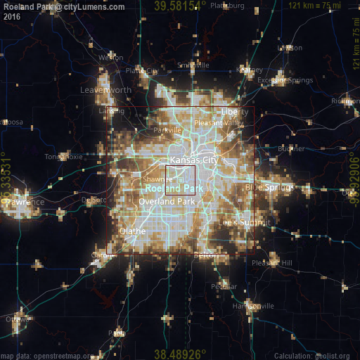
Analysis of Roeland Park night lights 2016
Square area 10x10 km:
 50.81%
90-99
32.95%80-89
15.75%70-79
0.49%60-69
0%50-59
0%40-49
0%30-39
0%20-29
0%10-19
0%0-9
0%Square area 50x50 km:
20.06%90-99
19.32%80-89
10.63%70-79
8.23%60-69
9.19%50-59
8.03%40-49
6.12%30-39
5.24%20-29
5.03%10-19
5.32%0-9
2.81%Clear (daylight) street map image can be seen on geolist.org.
Map coordinates:
39° 34' 53.5" North, 95° 20' 7.1" West
39° 2' 15" North, 94° 37' 55.8" West
38° 29' 21.3" North, 93° 55' 44.6" West
Some cities around Roeland Park sort by population:
• Kansas City
8.3 km =5.2 mi,  33°
33°
• Overland Park
7 km =4.3 mi,  208°
208°
• Kansas City
8.5 km =5.3 mi,  2°
2°
• Shawnee
7.6 km =4.7 mi,  273°
273°
• Leawood
8 km =5 mi,  170°
170°
• Prairie Village
5.1 km =3.2 mi,  181°
181°
• Merriam
5.5 km =3.4 mi,  253°
253°
• Mission
2.3 km =1.4 mi,  242°
242°
4278272 (p: 6,827)
Sources (retrieved 2019-11-25):
» Earth at Night: Flat Maps 2012, 2016