Redland night lights from space
Night Light of Redland (Maryland) from space (United States) Src. Average luminocity for 10x10km area is 75.0649% and for 50x50km: 54.1616%.
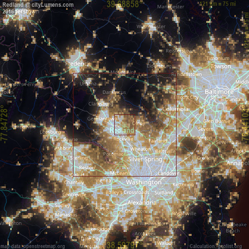
Analysis of Redland night lights 2016
Square area 10x10 km:
 17.53%
90-99
16.4%80-89
5.03%70-79
14.94%60-69
24.35%50-59
13.96%40-49
5.68%30-39
1.14%20-29
0.97%10-19
0%0-9
0%Square area 50x50 km:
13.15%90-99
10.82%80-89
6.75%70-79
8.43%60-69
9.1%50-59
8.72%40-49
5.02%30-39
5.01%20-29
6.98%10-19
12.96%0-9
13.06%Clear (daylight) street map image can be seen on geolist.org.
Map coordinates:
39° 41' 18.9" North, 77° 50' 50.2" West
39° 8' 43.4" North, 77° 8' 38.9" West
38° 35' 52.7" North, 76° 26' 27.7" West
Some cities around Redland sort by population:
• Gaithersburg
4.9 km =3 mi,  267°
267°
• Rockville
6.9 km =4.3 mi,  186°
186°
• Aspen Hill
9.6 km =6 mi,  140°
140°
• Olney
6.7 km =4.2 mi,  82°
82°
• Montgomery Village
5.6 km =3.5 mi,  308°
308°
• Leisure World
8.1 km =5 mi,  126°
126°
• Rossmoor
7.8 km =4.8 mi, 126°
• Layhill
10.4 km =6.5 mi,  124°
124°
4366593 (p: 17,242)
Sources (retrieved 2019-11-25):
» Earth at Night: Flat Maps 2012, 2016