Rossmoor night lights from space
Night Light of Rossmoor (Maryland) from space (United States) Src. Average luminocity for 10x10km area is 75.0341% and for 50x50km: 64.8951%.
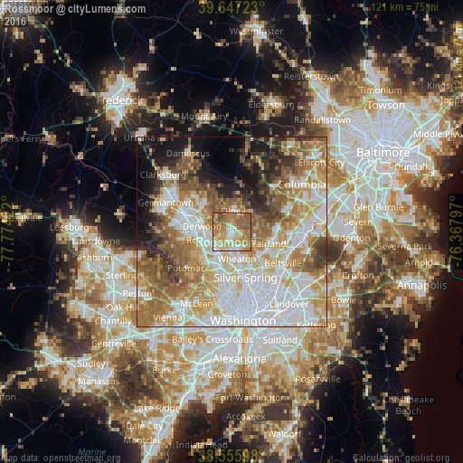
Analysis of Rossmoor night lights 2016
Square area 10x10 km:
 10.55%
90-99
13.64%80-89
13.96%70-79
18.67%60-69
24.51%50-59
16.4%40-49
2.27%30-39
0%20-29
0%10-19
0%0-9
0%Square area 50x50 km:
18.1%90-99
13.78%80-89
8.42%70-79
10.37%60-69
11.08%50-59
9.11%40-49
5.12%30-39
4.72%20-29
5.04%10-19
7.82%0-9
6.44%Clear (daylight) street map image can be seen on geolist.org.
Map coordinates:
39° 38' 50" North, 77° 46' 27.2" West
39° 6' 13.4" North, 77° 4' 15.9" West
38° 33' 21.5" North, 76° 22' 4.7" West
Some cities around Rossmoor sort by population:
• Aspen Hill
2.7 km =1.7 mi,  183°
183°
• Wheaton
7.2 km =4.5 mi,  169°
169°
• Olney
5.5 km =3.4 mi,  3°
3°
• Cloverly
6.3 km =3.9 mi,  85°
85°
• Colesville
6.7 km =4.2 mi,  117°
117°
• Glenmont
5.4 km =3.4 mi,  160°
160°
• Leisure World
0.2 km =0.1 mi,  130°
130°
• Layhill
2.6 km =1.6 mi, 118°
4367417 (p: 8,453)
Sources (retrieved 2019-11-25):
» Earth at Night: Flat Maps 2012, 2016