Red Hill night lights from space
Night Light of Red Hill (South Carolina) from space (United States) Src. Average luminocity for 10x10km area is 3.7098% and for 50x50km: 10.4486%.
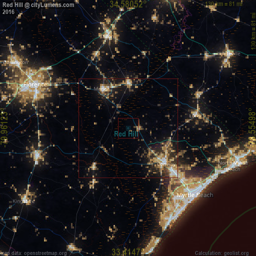
Analysis of Red Hill night lights 2016
Square area 10x10 km:
 0%
0%90-99
0%80-89
0.7%70-79
0.17%60-69
1.22%50-59
0.7%40-49
0.17%30-39
2.27%20-29
0%10-19
0%0-9
94.76%Square area 50x50 km:
0.73%90-99
0.74%80-89
1.89%70-79
1.34%60-69
1.97%50-59
1.04%40-49
2.03%30-39
3.29%20-29
3.06%10-19
6.67%0-9
77.23%Clear (daylight) street map image can be seen on geolist.org.
Map coordinates:
34° 34' 49.9" North, 79° 57' 40.4" West
33° 59' 58.6" North, 79° 15' 29.2" West
33° 24' 52.9" North, 78° 33' 17.9" West
Some cities around Red Hill sort by population:
• Florence
51.3 km =31.9 mi,  295°
295°
• Myrtle Beach
48.7 km =30.3 mi,  135°
135°
• Conway
26.6 km =16.5 mi,  133°
133°
• Socastee
42.6 km =26.5 mi,  145°
145°
• Garden City
50.8 km =31.6 mi, 152°
• Lake City
48 km =29.8 mi,  252°
252°
• Marion
23.8 km =14.8 mi,  326°
326°
• Dillon
47.5 km =29.5 mi,  347°
347°
4592485 (p: 13,223)
Sources (retrieved 2019-11-25):
» Earth at Night: Flat Maps 2012, 2016