Conway night lights from space
Night Light of Conway (South Carolina) from space (United States) Src. Average luminocity for 10x10km area is 63.9301% and for 50x50km: 22.269%.
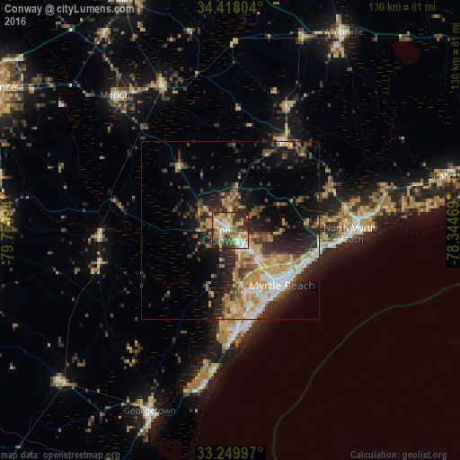

Analysis of Conway night lights 2016
Square area 10x10 km:
 11.19%
90-99
9.27%80-89
17.31%70-79
6.99%60-69
15.38%50-59
1.75%40-49
11.89%30-39
14.34%20-29
11.19%10-19
0.7%0-9
0%Square area 50x50 km:
2.68%90-99
2.91%80-89
3.84%70-79
3.66%60-69
3.82%50-59
2.03%40-49
3.45%30-39
4.66%20-29
7.03%10-19
9.72%0-9
56.22%Clear (daylight) street map image can be seen on geolist.org.
Map coordinates:
34° 25' 4.9" North, 79° 45' 3.4" West
33° 50' 9.6" North, 79° 2' 52.1" West
33° 14' 59.9" North, 78° 20' 40.9" West
Some cities around Conway sort by population:
• Myrtle Beach
22.1 km =13.7 mi,  137°
137°
• Socastee
17.6 km =10.9 mi,  164°
164°
• North Myrtle Beach
34 km =21.1 mi,  93°
93°
• Red Hill
26.6 km =16.5 mi,  313°
313°
• Garden City
27.3 km =17 mi,  172°
172°
• Little River
40.3 km =25 mi,  84°
84°
• Murrells Inlet
31.7 km =19.7 mi,  178°
178°
• Marion
50.1 km =31.1 mi,  319°
319°
4575461 (p: 21,053)
Sources (retrieved 2019-11-25):
» Earth at Night: Flat Maps 2012, 2016