Randolph night lights from space
Night Light of Randolph (Massachusetts) from space (United States) Src. Average luminocity for 10x10km area is 73.7303% and for 50x50km: 48.8259%.
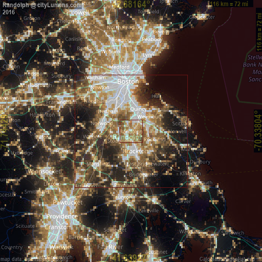

Analysis of Randolph night lights 2016
Square area 10x10 km:
 9.7%
9.7%90-99
16.97%80-89
10.3%70-79
14.39%60-69
26.97%50-59
14.55%40-49
6.52%30-39
0.61%20-29
0%10-19
0%0-9
0%Square area 50x50 km:
10.37%90-99
8.8%80-89
5.23%70-79
5.4%60-69
8.02%50-59
8.83%40-49
8.62%30-39
7.81%20-29
12.09%10-19
12.16%0-9
12.68%Clear (daylight) street map image can be seen on geolist.org.
Map coordinates:
42° 40' 53.9" North, 71° 44' 39.4" West
42° 9' 45.4" North, 71° 2' 28.2" West
41° 38' 21.4" North, 70° 20' 16.9" West
Some cities around Randolph sort by population:
• Brockton
9 km =5.6 mi,  167°
167°
• Quincy
10.5 km =6.5 mi,  17°
17°
• Braintree
5.6 km =3.5 mi,  35°
35°
• Milton
9.9 km =6.2 mi,  347°
347°
• Stoughton
6.5 km =4 mi,  230°
230°
• Canton
8.6 km =5.3 mi,  266°
266°
• Abington
10.2 km =6.3 mi,  129°
129°
• Holbrook
2.8 km =1.7 mi,  107°
107°
4948403 (p: 32,112)
Sources (retrieved 2019-11-25):
» Earth at Night: Flat Maps 2012, 2016