Port Washington night lights from space
Night Light of Port Washington (Wisconsin) from space (United States) Src. Average luminocity for 10x10km area is 24.6238% and for 50x50km: 11.6651%.
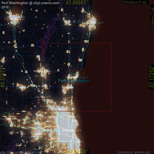
Analysis of Port Washington night lights 2016
Square area 10x10 km:
 3.81%
3.81%90-99
3.81%80-89
2.86%70-79
2.86%60-69
1.9%50-59
1.75%40-49
3.81%30-39
3.81%20-29
9.05%10-19
28.41%0-9
37.94%Square area 50x50 km:
1.5%90-99
1.91%80-89
1.65%70-79
1.03%60-69
1.42%50-59
1.94%40-49
2.03%30-39
1.56%20-29
4.07%10-19
7.1%0-9
75.78%Clear (daylight) street map image can be seen on geolist.org.
Map coordinates:
43° 53' 45.8" North, 88° 34' 43.6" West
43° 23' 14" North, 87° 52' 32.3" West
42° 52' 26.7" North, 87° 10' 21.1" West
Some cities around Port Washington sort by population:
• West Bend
25.2 km =15.7 mi,  279°
279°
• Mequon
22.8 km =14.2 mi,  213°
213°
• Germantown
25.9 km =16.1 mi,  227°
227°
• Brown Deer
25.9 km =16.1 mi,  196°
196°
• Grafton
9.8 km =6.1 mi,  219°
219°
• Cedarburg
13.5 km =8.4 mi, 221°
• Jackson
24.6 km =15.3 mi,  253°
253°
• Fox Point
25.6 km =15.9 mi,  184°
184°
5267776 (p: 11,576)
Sources (retrieved 2019-11-25):
» Earth at Night: Flat Maps 2012, 2016