Jackson night lights from space
Night Light of Jackson (Wisconsin) from space (United States) Src. Average luminocity for 10x10km area is 23.3318% and for 50x50km: 24.234%.
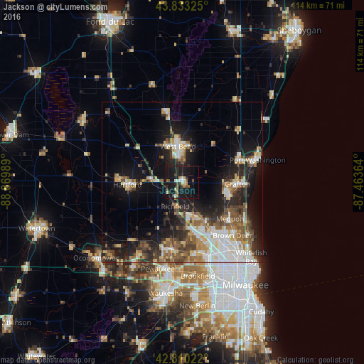
Analysis of Jackson night lights 2016
Square area 10x10 km:
 1.97%
1.97%90-99
2.27%80-89
2.58%70-79
1.97%60-69
3.64%50-59
1.82%40-49
3.64%30-39
1.52%20-29
6.97%10-19
50.61%0-9
23.03%Square area 50x50 km:
4.09%90-99
4.16%80-89
3.17%70-79
2.36%60-69
3.05%50-59
3.65%40-49
3.9%30-39
3.15%20-29
6.66%10-19
14.84%0-9
50.96%Clear (daylight) street map image can be seen on geolist.org.
Map coordinates:
43° 49' 59.7" North, 88° 52' 11.6" West
43° 19' 26" North, 88° 10' 0.3" West
42° 48' 36.8" North, 87° 27' 49.1" West
Some cities around Jackson sort by population:
• Menomonee Falls
16.6 km =10.3 mi,  166°
166°
• West Bend
11.4 km =7.1 mi,  353°
353°
• Mequon
16.4 km =10.2 mi,  137°
137°
• Germantown
11.5 km =7.1 mi,  156°
156°
• Hartford
17.2 km =10.7 mi,  267°
267°
• Richfield
7.9 km =4.9 mi,  196°
196°
• Cedarburg
14.8 km =9.2 mi,  101°
101°
• Slinger
9.7 km =6 mi,  276°
276°
5257669 (p: 6,859)
Sources (retrieved 2019-11-25):
» Earth at Night: Flat Maps 2012, 2016