Grafton night lights from space
Night Light of Grafton (Wisconsin) from space (United States) Src. Average luminocity for 10x10km area is 40.2515% and for 50x50km: 21.3331%.
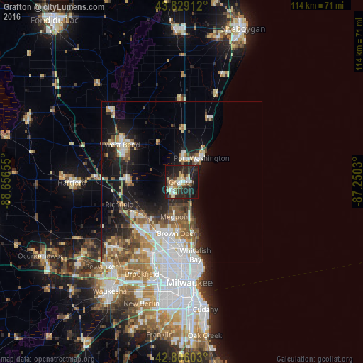
Analysis of Grafton night lights 2016
Square area 10x10 km:
 4.85%
4.85%90-99
6.21%80-89
8.48%70-79
2.58%60-69
5.91%50-59
2.88%40-49
2.88%30-39
9.85%20-29
26.36%10-19
25%0-9
5%Square area 50x50 km:
4.22%90-99
4.05%80-89
2.53%70-79
2.13%60-69
2.55%50-59
3.2%40-49
3.25%30-39
2.38%20-29
5.54%10-19
11.55%0-9
58.6%Clear (daylight) street map image can be seen on geolist.org.
Map coordinates:
43° 49' 44.8" North, 88° 39' 23.6" West
43° 19' 11" North, 87° 57' 12.3" West
42° 48' 21.7" North, 87° 15' 1.1" West
Some cities around Grafton sort by population:
• Menomonee Falls
20.5 km =12.7 mi,  220°
220°
• Mequon
13.1 km =8.1 mi,  208°
208°
• Germantown
16.3 km =10.1 mi,  231°
231°
• Brown Deer
17.4 km =10.8 mi,  182°
182°
• Port Washington
9.8 km =6.1 mi,  39°
39°
• Cedarburg
3.8 km =2.4 mi, 227°
• Jackson
17.3 km =10.7 mi,  271°
271°
• Fox Point
18.5 km =11.5 mi,  166°
166°
5254739 (p: 11,527)
Sources (retrieved 2019-11-25):
» Earth at Night: Flat Maps 2012, 2016