Maplewood night lights from space
Night Light of Maplewood (Washington) from space (United States) Src. Average luminocity for 10x10km area is 6.1548% and for 50x50km: 31.9531%.
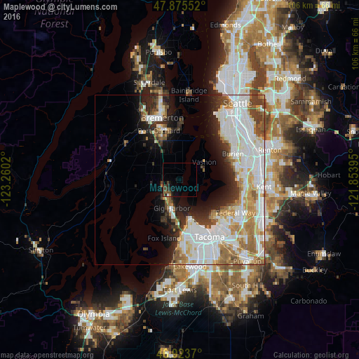
Analysis of Maplewood night lights 2016
Square area 10x10 km:
 0.43%
0.43%90-99
0.14%80-89
0%70-79
0.57%60-69
0.57%50-59
1.42%40-49
2.84%30-39
1.42%20-29
2.27%10-19
3.98%0-9
86.36%Square area 50x50 km:
10.84%90-99
7.94%80-89
2.75%70-79
3.36%60-69
3.54%50-59
2.91%40-49
2.62%30-39
2.76%20-29
4.43%10-19
6.6%0-9
52.25%Clear (daylight) street map image can be seen on geolist.org.
Map coordinates:
47° 52' 31.9" North, 123° 15' 36.7" West
47° 24' 6.3" North, 122° 33' 25.5" West
46° 55' 25.3" North, 121° 51' 14.2" West
Some cities around Maplewood sort by population:
• Port Orchard
16.5 km =10.3 mi,  338°
338°
• Artondale
12.3 km =7.6 mi,  202°
202°
• Vashon
8.9 km =5.5 mi,  55°
55°
• Gig Harbor
8.2 km =5.1 mi,  192°
192°
• Parkwood
15.1 km =9.4 mi, 344°
• Normandy Park
16.7 km =10.4 mi,  76°
76°
• Wollochet
14.9 km =9.3 mi, 187°
• East Port Orchard
14.4 km =8.9 mi, 339°
5802349 (p: 5,138)
Sources (retrieved 2019-11-25):
» Earth at Night: Flat Maps 2012, 2016