Plum night lights from space
Night Light of Plum (Pennsylvania) from space (United States) Src. Average luminocity for 10x10km area is 48.7568% and for 50x50km: 42.3985%.

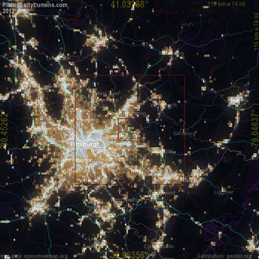
Analysis of Plum night lights 2016
Square area 10x10 km:
 0.85%
0.85%90-99
3.57%80-89
7.65%70-79
4.76%60-69
9.01%50-59
21.77%40-49
20.07%30-39
9.86%20-29
12.76%10-19
9.69%0-9
0%Square area 50x50 km:
6.65%90-99
7.47%80-89
5.22%70-79
6.05%60-69
8.1%50-59
8.6%40-49
7.81%30-39
5.99%20-29
8.58%10-19
10.01%0-9
25.53%Clear (daylight) street map image can be seen on geolist.org.
Map coordinates:
41° 1' 58.4" North, 80° 27' 9.4" West
40° 30' 1.3" North, 79° 44' 58.2" West
39° 57' 48.8" North, 79° 2' 46.9" West
Some cities around Plum sort by population:
• Penn Hills
7.6 km =4.7 mi,  270°
270°
• Monroeville
9.4 km =5.8 mi,  200°
200°
• Murrysville
9.1 km =5.7 mi,  151°
151°
• New Kensington
7.8 km =4.8 mi,  350°
350°
• Lower Burrell
5.9 km =3.7 mi, 353°
• Oakmont
8.2 km =5.1 mi,  286°
286°
• Fox Chapel
11.1 km =6.9 mi,  277°
277°
• Turtle Creek
12.3 km =7.6 mi,  211°
211°
5206606 (p: 27,505)
Sources (retrieved 2019-11-25):
» Earth at Night: Flat Maps 2012, 2016