Platteville night lights from space
Night Light of Platteville (Wisconsin) from space (United States) Src. Average luminocity for 10x10km area is 14.2121% and for 50x50km: 3.5781%.
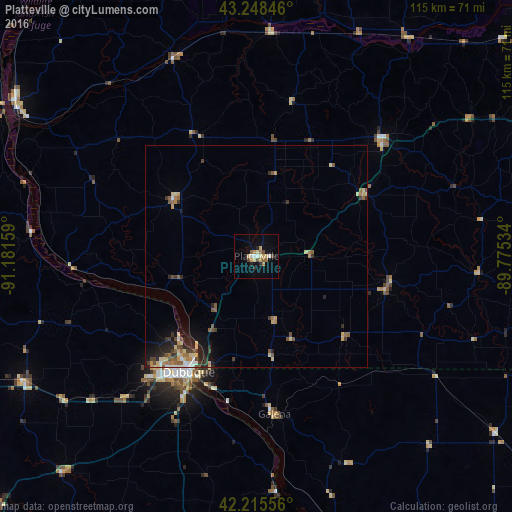
Analysis of Platteville night lights 2016
Square area 10x10 km:
 1.06%
1.06%90-99
1.52%80-89
2.88%70-79
2.88%60-69
1.97%50-59
1.21%40-49
2.42%30-39
0%20-29
1.82%10-19
3.33%0-9
80.91%Square area 50x50 km:
0.18%90-99
0.29%80-89
0.76%70-79
0.6%60-69
0.48%50-59
0.63%40-49
0.59%30-39
0.64%20-29
0.83%10-19
1.55%0-9
93.44%Clear (daylight) street map image can be seen on geolist.org.
Map coordinates:
43° 14' 54.5" North, 91° 10' 53.7" West
42° 44' 3" North, 90° 28' 42.5" West
42° 12' 56" North, 89° 46' 31.2" West
Some cities around Platteville sort by population:
• Dubuque
30.1 km =18.7 mi,  210°
210°
• Verona
82.2 km =51.1 mi,  69°
69°
• Monroe
70.3 km =43.7 mi,  102°
102°
• Mount Horeb
67.6 km =42 mi,  63°
63°
• Maquoketa
75.5 km =46.9 mi,  191°
191°
• Prairie du Chien
64.5 km =40.1 mi,  303°
303°
• Asbury
33.1 km =20.6 mi,  222°
222°
• Richland Center
67.2 km =41.8 mi,  6°
6°
5267332 (p: 12,572)
Sources (retrieved 2019-11-25):
» Earth at Night: Flat Maps 2012, 2016