Monroe night lights from space
Night Light of Monroe (Wisconsin) from space (United States) Src. Average luminocity for 10x10km area is 17.503% and for 50x50km: 1.7962%.
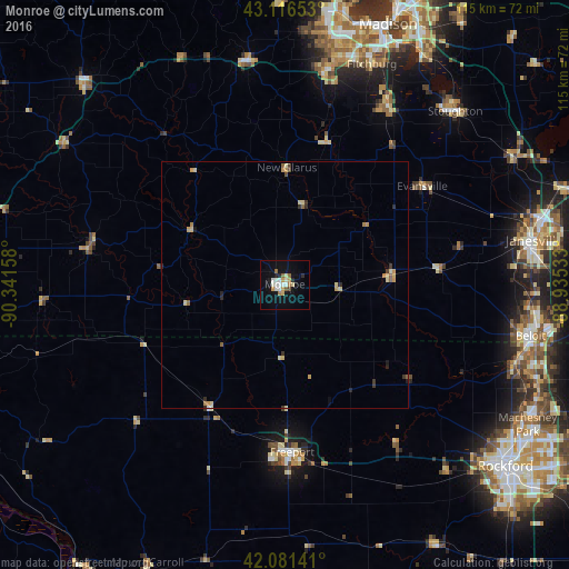
Analysis of Monroe night lights 2016
Square area 10x10 km:
 3.18%
3.18%90-99
3.48%80-89
1.82%70-79
2.42%60-69
1.36%50-59
2.12%40-49
0.76%30-39
0%20-29
2.12%10-19
11.67%0-9
71.06%Square area 50x50 km:
0.13%90-99
0.2%80-89
0.42%70-79
0.35%60-69
0.19%50-59
0.25%40-49
0.1%30-39
0.2%20-29
0.33%10-19
0.56%0-9
97.27%Clear (daylight) street map image can be seen on geolist.org.
Map coordinates:
43° 6' 59.5" North, 90° 20' 29.7" West
42° 36' 4" North, 89° 38' 18.4" West
42° 4' 53.1" North, 88° 56' 7.2" West
Some cities around Monroe sort by population:
• Fitchburg
42.3 km =26.3 mi,  18°
18°
• Freeport
33.9 km =21.1 mi,  177°
177°
• Stoughton
49.1 km =30.5 mi,  44°
44°
• Verona
44.2 km =27.5 mi,  11°
11°
• Oregon
41.7 km =25.9 mi,  29°
29°
• Rockton
49.2 km =30.6 mi,  109°
109°
• Mount Horeb
46 km =28.6 mi,  349°
349°
• Evansville
34.1 km =21.2 mi,  54°
54°
5263331 (p: 10,796)
Sources (retrieved 2019-11-25):
» Earth at Night: Flat Maps 2012, 2016