Plainfield night lights from space
Night Light of Plainfield (Connecticut) from space (United States) Src. Average luminocity for 10x10km area is 14.7679% and for 50x50km: 7.698%.
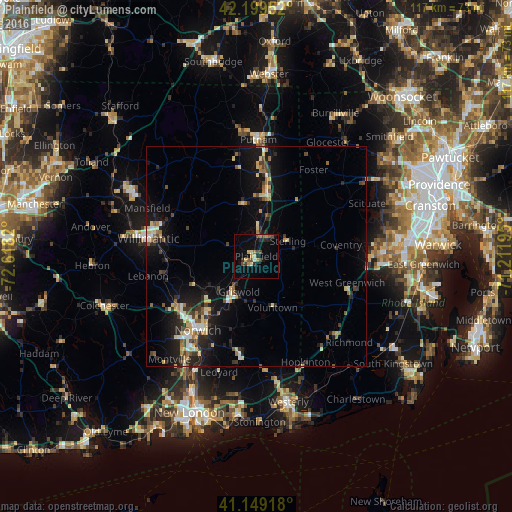
Analysis of Plainfield night lights 2016
Square area 10x10 km:
 0.32%
0.32%90-99
0.97%80-89
2.44%70-79
3.41%60-69
0.65%50-59
2.27%40-49
4.71%30-39
0.32%20-29
3.08%10-19
6.49%0-9
75.32%Square area 50x50 km:
0.54%90-99
0.93%80-89
1.34%70-79
0.64%60-69
0.91%50-59
0.97%40-49
1.13%30-39
1.07%20-29
2.57%10-19
6.54%0-9
83.35%Clear (daylight) street map image can be seen on geolist.org.
Map coordinates:
42° 11' 58.3" North, 72° 37' 5.5" West
41° 40' 35.4" North, 71° 54' 54.3" West
41° 8' 57" North, 71° 12' 43" West
Some cities around Plainfield sort by population:
• Norwich
21.6 km =13.4 mi,  218°
218°
• Coventry
19.5 km =12.1 mi,  82°
82°
• Windham
20.3 km =12.6 mi,  277°
277°
• Willimantic
24.6 km =15.3 mi, 278°
• Killingly Center
18.4 km =11.4 mi,  11°
11°
• Hopkinton
26.5 km =16.5 mi,  154°
154°
• Putnam
26.5 km =16.5 mi,  1°
1°
• West Greenwich
21.6 km =13.4 mi,  101°
101°
4840755 (p: 15,498)
Sources (retrieved 2019-11-25):
» Earth at Night: Flat Maps 2012, 2016