Norwich night lights from space
Night Light of Norwich (Connecticut) from space (United States) Src. Average luminocity for 10x10km area is 51.2925% and for 50x50km: 15.0793%.
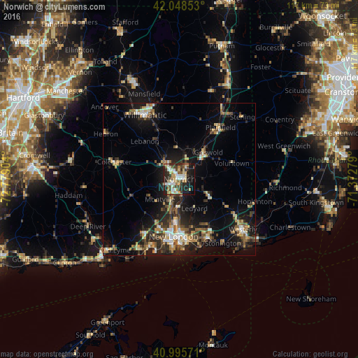

Analysis of Norwich night lights 2016
Square area 10x10 km:
 9.01%
9.01%90-99
11.22%80-89
10.54%70-79
5.1%60-69
3.06%50-59
5.95%40-49
7.14%30-39
8.33%20-29
18.37%10-19
18.54%0-9
2.72%Square area 50x50 km:
1.41%90-99
1.94%80-89
2.29%70-79
1.78%60-69
1.73%50-59
2.17%40-49
2.38%30-39
2.38%20-29
5.55%10-19
11.28%0-9
67.08%Clear (daylight) street map image can be seen on geolist.org.
Map coordinates:
42° 2' 54.7" North, 72° 46' 44.5" West
41° 31' 27.3" North, 72° 4' 33.3" West
40° 59' 44.6" North, 71° 22' 22" West
Some cities around Norwich sort by population:
• New London
18.9 km =11.7 mi,  185°
185°
• Windham
20.7 km =12.9 mi,  340°
340°
• Montville Center
8 km =5 mi,  231°
231°
• Waterford
20.9 km =13 mi, 193°
• Plainfield
21.6 km =13.4 mi,  38°
38°
• Ledyard
10.7 km =6.6 mi,  151°
151°
• Groton
19.4 km =12.1 mi,  180°
180°
• Conning Towers-Nautilus Park
15.4 km =9.6 mi, 177°
4839843 (p: 39,899)
Sources (retrieved 2019-11-25):
» Earth at Night: Flat Maps 2012, 2016