Killingly Center night lights from space
Night Light of Killingly Center (Connecticut) from space (United States) Src. Average luminocity for 10x10km area is 20.4778% and for 50x50km: 6.9297%.
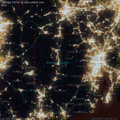
Analysis of Killingly Center night lights 2016
Square area 10x10 km:
 0.48%
0.48%90-99
2.22%80-89
4.44%70-79
2.06%60-69
4.6%50-59
1.75%40-49
4.44%30-39
2.86%20-29
2.7%10-19
26.35%0-9
48.1%Square area 50x50 km:
0.19%90-99
0.49%80-89
0.93%70-79
1.01%60-69
0.71%50-59
1.15%40-49
1.18%30-39
0.8%20-29
1.94%10-19
7.38%0-9
84.21%Clear (daylight) street map image can be seen on geolist.org.
Map coordinates:
42° 21' 37.5" North, 72° 34' 20.5" West
41° 50' 19.4" North, 71° 52' 9.3" West
41° 18' 45.8" North, 71° 9' 58" West
Some cities around Killingly Center sort by population:
• Coventry
21.8 km =13.5 mi,  134°
134°
• Plainfield
18.4 km =11.4 mi,  191°
191°
• Webster
23.5 km =14.6 mi,  357°
357°
• North Scituate
23.4 km =14.5 mi,  91°
91°
• Dudley
23.5 km =14.6 mi,  347°
347°
• Thompson
13.4 km =8.3 mi,  2°
2°
• Putnam
9.1 km =5.7 mi,  338°
338°
• Douglas
26.3 km =16.3 mi,  24°
24°
4837278 (p: 17,282)
Sources (retrieved 2019-11-25):
» Earth at Night: Flat Maps 2012, 2016