West Greenwich night lights from space
Night Light of West Greenwich (Rhode Island) from space (United States) Src. Average luminocity for 10x10km area is 5.6494% and for 50x50km: 19.709%.
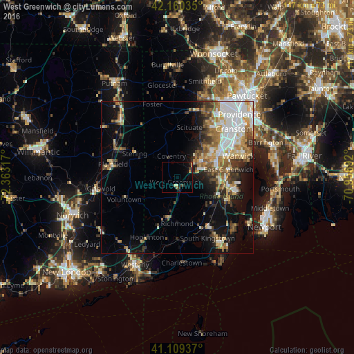
Analysis of West Greenwich night lights 2016
Square area 10x10 km:
 0%
0%90-99
0.16%80-89
1.3%70-79
1.14%60-69
0.65%50-59
0%40-49
1.3%30-39
0.97%20-29
2.27%10-19
2.11%0-9
90.1%Square area 50x50 km:
4.34%90-99
3.45%80-89
2.33%70-79
2.59%60-69
2.64%50-59
2.55%40-49
2.37%30-39
2.55%20-29
3.15%10-19
8.29%0-9
65.73%Clear (daylight) street map image can be seen on geolist.org.
Map coordinates:
42° 9' 37.3" North, 72° 21' 47.4" West
41° 38' 13.2" North, 71° 39' 36.1" West
41° 6' 33.7" North, 70° 57' 24.9" West
Some cities around West Greenwich sort by population:
• Warwick
21.4 km =13.3 mi,  70°
70°
• Coventry
7.3 km =4.5 mi,  344°
344°
• North Kingstown
18.8 km =11.7 mi,  120°
120°
• Plainfield
21.6 km =13.4 mi,  281°
281°
• East Greenwich
17.2 km =10.7 mi,  81°
81°
• Hopkinton
21.9 km =13.6 mi,  206°
206°
• Kingston
20.8 km =12.9 mi,  146°
146°
• Exeter
12.1 km =7.5 mi, 122°
8260172 (p: 6,135)
Sources (retrieved 2019-11-25):
» Earth at Night: Flat Maps 2012, 2016