Vashon night lights from space
Night Light of Vashon (Washington) from space (United States) Src. Average luminocity for 10x10km area is 2.9872% and for 50x50km: 40.5208%.
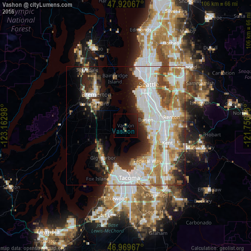
Analysis of Vashon night lights 2016
Square area 10x10 km:
 0%
0%90-99
0%80-89
0%70-79
0.57%60-69
0%50-59
0.57%40-49
0.57%30-39
0%20-29
1.14%10-19
5.4%0-9
91.76%Square area 50x50 km:
12.92%90-99
9.75%80-89
3.54%70-79
4.64%60-69
5.16%50-59
3.77%40-49
3.84%30-39
4.34%20-29
5.64%10-19
7.86%0-9
38.55%Clear (daylight) street map image can be seen on geolist.org.
Map coordinates:
47° 55' 14.4" North, 123° 9' 46.7" West
47° 26' 50.4" North, 122° 27' 35.5" West
46° 58' 10.8" North, 121° 45' 24.2" West
Some cities around Vashon sort by population:
• Burien
8.9 km =5.5 mi,  73°
73°
• Des Moines
11.4 km =7.1 mi,  116°
116°
• SeaTac
12.6 km =7.8 mi,  89°
89°
• White Center
11.1 km =6.9 mi,  45°
45°
• Normandy Park
9 km =5.6 mi,  97°
97°
• Riverton
13.1 km =8.1 mi, 71°
• Boulevard Park
11.8 km =7.3 mi, 66°
• Maplewood
8.9 km =5.5 mi,  235°
235°
5814647 (p: 10,624)
Sources (retrieved 2019-11-25):
» Earth at Night: Flat Maps 2012, 2016