Palos Verdes Estates night lights from space
Night Light of Palos Verdes Estates (California) from space (United States) Src. Average luminocity for 10x10km area is 55.201% and for 50x50km: 39.2499%.
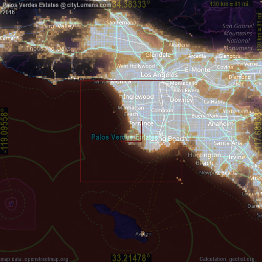
Analysis of Palos Verdes Estates night lights 2016
Square area 10x10 km:
 11.36%
90-99
11.54%80-89
3.32%70-79
4.2%60-69
15.73%50-59
13.99%40-49
6.82%30-39
4.72%20-29
8.04%10-19
13.64%0-9
6.64%Square area 50x50 km:
25.82%90-99
7.69%80-89
0.71%70-79
0.71%60-69
1.7%50-59
1.76%40-49
1.47%30-39
1.45%20-29
2.62%10-19
4.2%0-9
51.89%Clear (daylight) street map image can be seen on geolist.org.
Map coordinates:
34° 22' 60" North, 119° 5' 44.1" West
33° 48' 3.8" North, 118° 23' 32.8" West
33° 12' 53.2" North, 117° 41' 21.6" West
Some cities around Palos Verdes Estates sort by population:
• Torrance
6.2 km =3.9 mi,  51°
51°
• Redondo Beach
5.4 km =3.4 mi,  3°
3°
• Rancho Palos Verdes
6.3 km =3.9 mi,  175°
175°
• Manhattan Beach
9.5 km =5.9 mi,  349°
349°
• West Carson
9.5 km =5.9 mi,  76°
76°
• Lomita
7.2 km =4.5 mi,  97°
97°
• Hermosa Beach
6.8 km =4.2 mi, 354°
• Rolling Hills Estates
3.5 km =2.2 mi,  114°
114°
5380883 (p: 13,682)
Sources (retrieved 2019-11-25):
» Earth at Night: Flat Maps 2012, 2016