Oxford night lights from space
Night Light of Oxford (North Carolina) from space (United States) Src. Average luminocity for 10x10km area is 29.1311% and for 50x50km: 8.9214%.
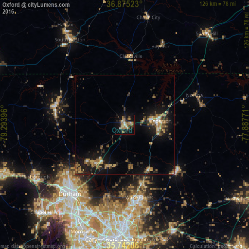
Analysis of Oxford night lights 2016
Square area 10x10 km:
 2.1%
2.1%90-99
2.8%80-89
2.45%70-79
5.77%60-69
8.57%50-59
3.67%40-49
2.8%30-39
5.59%20-29
5.94%10-19
28.67%0-9
31.64%Square area 50x50 km:
0.53%90-99
0.5%80-89
1.22%70-79
1.32%60-69
1.77%50-59
1.32%40-49
1.02%30-39
2.27%20-29
2.3%10-19
8.67%0-9
79.09%Clear (daylight) street map image can be seen on geolist.org.
Map coordinates:
36° 52' 30.8" North, 79° 17' 38.3" West
36° 18' 38.5" North, 78° 35' 27" West
35° 44' 31.4" North, 77° 53' 15.8" West
Some cities around Oxford sort by population:
• Durham
44.8 km =27.8 mi,  218°
218°
• Wake Forest
37.5 km =23.3 mi,  168°
168°
• Henderson
17.3 km =10.7 mi,  83°
83°
• Roxboro
36.3 km =22.6 mi,  284°
284°
• South Boston
51.3 km =31.9 mi,  327°
327°
• Butner
24.8 km =15.4 mi, 216°
• Hillsborough
52.6 km =32.7 mi,  240°
240°
• Rolesville
44.7 km =27.8 mi,  164°
164°
4483745 (p: 8,742)
Sources (retrieved 2019-11-25):
» Earth at Night: Flat Maps 2012, 2016