Wake Forest night lights from space
Night Light of Wake Forest (North Carolina) from space (United States) Src. Average luminocity for 10x10km area is 69.0568% and for 50x50km: 35.1996%.

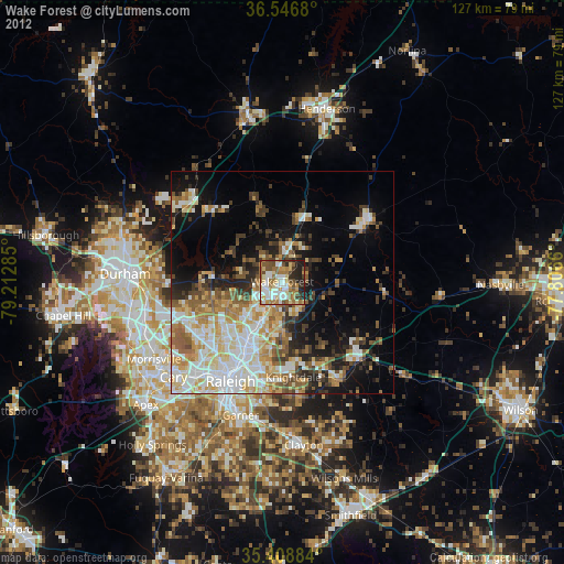
Analysis of Wake Forest night lights 2016
Square area 10x10 km:
 12.82%
90-99
13.74%80-89
13.55%70-79
9.89%60-69
15.75%50-59
8.97%40-49
9.89%30-39
7.69%20-29
7.51%10-19
0.18%0-9
0%Square area 50x50 km:
5.73%90-99
5.75%80-89
6.32%70-79
6.24%60-69
6.65%50-59
3.92%40-49
3.24%30-39
5.26%20-29
5.73%10-19
11.75%0-9
39.41%Clear (daylight) street map image can be seen on geolist.org.
Map coordinates:
36° 32' 48.5" North, 79° 12' 46.3" West
35° 58' 47.5" North, 78° 30' 35" West
35° 24' 31.8" North, 77° 48' 23.8" West
Some cities around Wake Forest sort by population:
• Raleigh
25.9 km =16.1 mi,  206°
206°
• West Raleigh
25.6 km =15.9 mi, 212°
• Cary
32.2 km =20 mi,  229°
229°
• Garner
31.3 km =19.4 mi,  197°
197°
• Knightdale
21.5 km =13.4 mi,  172°
172°
• Butner
27.9 km =17.3 mi,  307°
307°
• Rolesville
7.9 km =4.9 mi,  143°
143°
• Wendell
25.5 km =15.8 mi,  150°
150°
4497290 (p: 38,199)
Sources (retrieved 2019-11-25):
» Earth at Night: Flat Maps 2012, 2016