Hillsborough night lights from space
Night Light of Hillsborough (North Carolina) from space (United States) Src. Average luminocity for 10x10km area is 39.1245% and for 50x50km: 26.4012%.
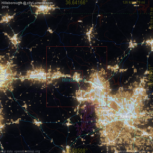
Analysis of Hillsborough night lights 2016
Square area 10x10 km:
 3.11%
3.11%90-99
3.85%80-89
6.41%70-79
6.96%60-69
13.92%50-59
2.38%40-49
3.66%30-39
5.86%20-29
8.24%10-19
41.03%0-9
4.58%Square area 50x50 km:
4.76%90-99
4.44%80-89
4.7%70-79
4%60-69
4.8%50-59
2.44%40-49
2.79%30-39
4.07%20-29
5.27%10-19
10.12%0-9
52.6%Clear (daylight) street map image can be seen on geolist.org.
Map coordinates:
36° 38' 30" North, 79° 48' 10.3" West
36° 4' 31.5" North, 79° 5' 59" West
35° 30' 18.3" North, 78° 23' 47.8" West
Some cities around Hillsborough sort by population:
• Durham
20.2 km =12.6 mi,  116°
116°
• Chapel Hill
18.5 km =11.5 mi,  167°
167°
• Burlington
30.5 km =19 mi,  274°
274°
• Carrboro
18.5 km =11.5 mi, 173°
• Graham
27 km =16.8 mi, 268°
• Mebane
15.2 km =9.4 mi,  278°
278°
• Elon
36.7 km =22.8 mi, 274°
• Butner
31.5 km =19.6 mi,  78°
78°
4471241 (p: 6,415)
Sources (retrieved 2019-11-25):
» Earth at Night: Flat Maps 2012, 2016