Rolesville night lights from space
Night Light of Rolesville (North Carolina) from space (United States) Src. Average luminocity for 10x10km area is 46.4103% and for 50x50km: 36.208%.
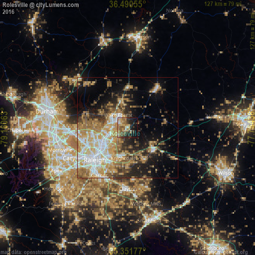
Analysis of Rolesville night lights 2016
Square area 10x10 km:
 3.48%
3.48%90-99
4.21%80-89
10.99%70-79
8.97%60-69
7.33%50-59
10.99%40-49
6.59%30-39
10.07%20-29
9.71%10-19
20.15%0-9
7.51%Square area 50x50 km:
5.72%90-99
5.61%80-89
6.59%70-79
6.42%60-69
6.62%50-59
4.51%40-49
3.84%30-39
5.74%20-29
6.62%10-19
10.88%0-9
37.46%Clear (daylight) street map image can be seen on geolist.org.
Map coordinates:
36° 29' 26" North, 79° 9' 38.3" West
35° 55' 23.6" North, 78° 27' 27" West
35° 21' 6.4" North, 77° 45' 15.8" West
Some cities around Rolesville sort by population:
• Raleigh
23.4 km =14.5 mi,  224°
224°
• West Raleigh
24 km =14.9 mi,  230°
230°
• Cary
32.6 km =20.3 mi,  243°
243°
• Wake Forest
7.9 km =4.9 mi,  323°
323°
• Garner
27.5 km =17.1 mi,  210°
210°
• Clayton
30.3 km =18.8 mi,  179°
179°
• Knightdale
15.2 km =9.4 mi,  187°
187°
• Wendell
17.7 km =11 mi,  153°
153°
4488859 (p: 6,289)
Sources (retrieved 2019-11-25):
» Earth at Night: Flat Maps 2012, 2016