Old Jamestown night lights from space
Night Light of Old Jamestown (Missouri) from space (United States) Src. Average luminocity for 10x10km area is 61.3163% and for 50x50km: 49.8255%.
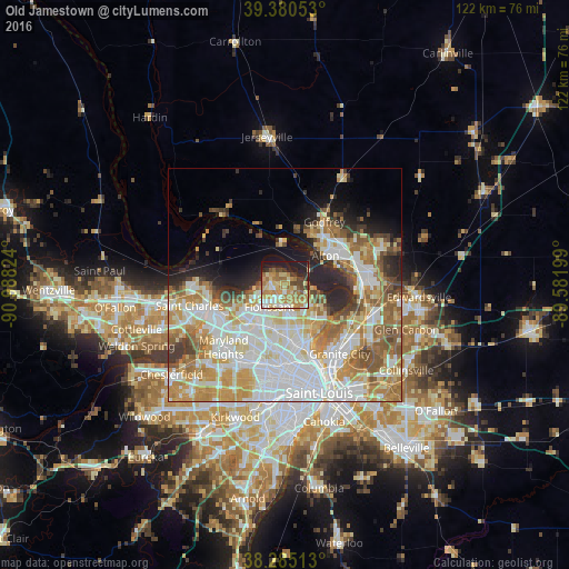
Analysis of Old Jamestown night lights 2016
Square area 10x10 km:
 6.46%
6.46%90-99
9.69%80-89
12.59%70-79
17.86%60-69
16.33%50-59
4.08%40-49
7.31%30-39
4.59%20-29
11.22%10-19
9.86%0-9
0%Square area 50x50 km:
13.87%90-99
11.48%80-89
6.7%70-79
8.24%60-69
7.09%50-59
5.83%40-49
3.36%30-39
3.27%20-29
5.59%10-19
5.75%0-9
28.82%Clear (daylight) street map image can be seen on geolist.org.
Map coordinates:
39° 22' 49.9" North, 90° 59' 17.7" West
38° 50' 5.8" North, 90° 17' 6.4" West
38° 17' 6.5" North, 89° 34' 55.2" West
Some cities around Old Jamestown sort by population:
• Florissant
6 km =3.7 mi,  212°
212°
• Alton
10.7 km =6.6 mi,  54°
54°
• Hazelwood
10.3 km =6.4 mi,  226°
226°
• Ferguson
10.2 km =6.3 mi,  189°
189°
• Spanish Lake
8 km =5 mi,  131°
131°
• Berkeley
9.8 km =6.1 mi,  204°
204°
• Black Jack
4.9 km =3 mi,  161°
161°
• Dellwood
9.5 km =5.9 mi,  180°
180°
7315274 (p: 19,184)
Sources (retrieved 2019-11-25):
» Earth at Night: Flat Maps 2012, 2016