Dellwood night lights from space
Night Light of Dellwood (Missouri) from space (United States) Src. Average luminocity for 10x10km area is 94.7619% and for 50x50km: 64.979%.
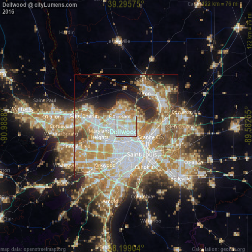
Analysis of Dellwood night lights 2016
Square area 10x10 km:
 37.93%
90-99
39.8%80-89
16.84%70-79
5.44%60-69
0%50-59
0%40-49
0%30-39
0%20-29
0%10-19
0%0-9
0%Square area 50x50 km:
19.01%90-99
15.81%80-89
9.16%70-79
11.51%60-69
8.89%50-59
6.3%40-49
3.62%30-39
3.28%20-29
5.65%10-19
4.97%0-9
11.79%Clear (daylight) street map image can be seen on geolist.org.
Map coordinates:
39° 17' 44.7" North, 90° 59' 19.7" West
38° 44' 58.2" North, 90° 17' 8.4" West
38° 11' 56.5" North, 89° 34' 57.2" West
Some cities around Dellwood sort by population:
• Florissant
5.5 km =3.4 mi,  324°
324°
• Ferguson
1.8 km =1.1 mi,  251°
251°
• Jennings
4 km =2.5 mi,  146°
146°
• Bellefontaine Neighbors
5.2 km =3.2 mi,  101°
101°
• Berkeley
4 km =2.5 mi,  278°
278°
• Saint Johns
6.4 km =4 mi,  231°
231°
• Black Jack
5.1 km =3.2 mi,  18°
18°
• Saint John
6.5 km =4 mi, 233°
4383713 (p: 5,011)
Sources (retrieved 2019-11-25):
» Earth at Night: Flat Maps 2012, 2016