Hazelwood night lights from space
Night Light of Hazelwood (Missouri) from space (United States) Src. Average luminocity for 10x10km area is 89.8639% and for 50x50km: 59.4525%.
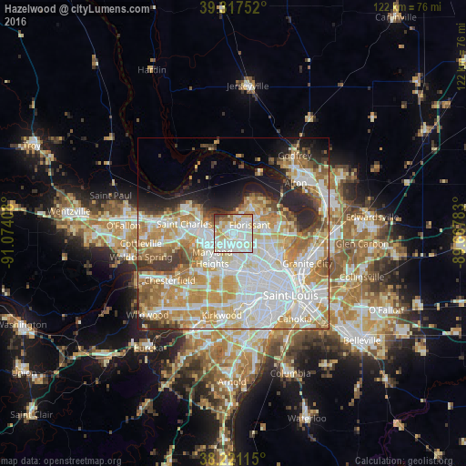
Analysis of Hazelwood night lights 2016
Square area 10x10 km:
 33.5%
33.5%90-99
34.69%80-89
11.9%70-79
8.5%60-69
3.91%50-59
3.57%40-49
2.55%30-39
1.36%20-29
0%10-19
0%0-9
0%Square area 50x50 km:
18.03%90-99
14.33%80-89
8.27%70-79
10.52%60-69
7.68%50-59
4.56%40-49
3.03%30-39
3.83%20-29
5.78%10-19
5.45%0-9
18.5%Clear (daylight) street map image can be seen on geolist.org.
Map coordinates:
39° 19' 3.1" North, 91° 4' 26.7" West
38° 46' 17.2" North, 90° 22' 15.4" West
38° 13' 16.1" North, 89° 40' 4.2" West
Some cities around Hazelwood sort by population:
• Florissant
4.6 km =2.9 mi,  64°
64°
• Ferguson
6.4 km =4 mi,  118°
118°
• Saint Ann
5 km =3.1 mi,  192°
192°
• Bridgeton
3.6 km =2.2 mi,  262°
262°
• Berkeley
3.9 km =2.4 mi, 118°
• Saint Johns
6.9 km =4.3 mi,  159°
159°
• Saint John
6.6 km =4.1 mi, 161°
• Dellwood
7.8 km =4.8 mi,  108°
108°
4389967 (p: 25,661)
Sources (retrieved 2019-11-25):
» Earth at Night: Flat Maps 2012, 2016