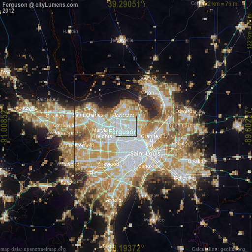
Ferguson night lights from space
Night Light of Ferguson (Missouri) from space (United States) Src. Average luminocity for 10x10km area is 96.131% and for 50x50km: 65.144%.
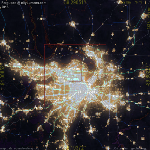
Analysis of Ferguson night lights 2016
Square area 10x10 km:
 40.99%
90-99
43.54%80-89
14.12%70-79
1.36%60-69
0%50-59
0%40-49
0%30-39
0%20-29
0%10-19
0%0-9
0%Square area 50x50 km:
19.19%90-99
15.94%80-89
9.13%70-79
11.57%60-69
8.83%50-59
5.99%40-49
3.66%30-39
3.45%20-29
5.66%10-19
4.82%0-9
11.76%Clear (daylight) street map image can be seen on geolist.org.
Map coordinates:
39° 17' 25.8" North, 91° 0' 30.7" West
38° 44' 39.2" North, 90° 18' 19.4" West
38° 11' 37.4" North, 89° 36' 8.2" West
Some cities around Ferguson sort by population:
• Florissant
5.2 km =3.2 mi,  343°
343°
• Hazelwood
6.4 km =4 mi,  298°
298°
• Jennings
4.8 km =3 mi,  125°
125°
• Berkeley
2.5 km =1.6 mi, 297°
• Saint Johns
4.7 km =2.9 mi,  223°
223°
• Black Jack
6.4 km =4 mi,  31°
31°
• Saint John
4.8 km =3 mi,  227°
227°
• Dellwood
1.8 km =1.1 mi,  71°
71°
4386387 (p: 21,059)
Sources (retrieved 2019-11-25):
» Earth at Night: Flat Maps 2012, 2016