Spanish Lake night lights from space
Night Light of Spanish Lake (Missouri) from space (United States) Src. Average luminocity for 10x10km area is 68.3946% and for 50x50km: 58.6355%.
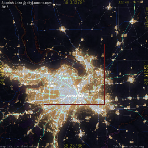
Analysis of Spanish Lake night lights 2016
Square area 10x10 km:
 8.33%
8.33%90-99
13.27%80-89
15.65%70-79
16.67%60-69
16.33%50-59
8.33%40-49
6.63%30-39
4.08%20-29
9.86%10-19
0.85%0-9
0%Square area 50x50 km:
17.33%90-99
14.01%80-89
7.69%70-79
9.49%60-69
8.38%50-59
6.2%40-49
3.7%30-39
3.18%20-29
5.39%10-19
6.01%0-9
18.62%Clear (daylight) street map image can be seen on geolist.org.
Map coordinates:
39° 20' 1.6" North, 90° 55' 8.7" West
38° 47' 16.2" North, 90° 12' 57.4" West
38° 14' 15.6" North, 89° 30' 46.2" West
Some cities around Spanish Lake sort by population:
• Florissant
9.2 km =5.7 mi,  270°
270°
• Ferguson
9.1 km =5.7 mi,  237°
237°
• Old Jamestown
8 km =5 mi,  311°
311°
• Jennings
8.5 km =5.3 mi,  206°
206°
• Bellefontaine Neighbors
5.4 km =3.4 mi,  189°
189°
• Black Jack
4.5 km =2.8 mi,  277°
277°
• Glasgow Village
4.1 km =2.5 mi,  158°
158°
• Dellwood
7.4 km =4.6 mi,  234°
234°
4409591 (p: 19,650)
Sources (retrieved 2019-11-25):
» Earth at Night: Flat Maps 2012, 2016