Terryville night lights from space
Night Light of Terryville (Connecticut) from space (United States) Src. Average luminocity for 10x10km area is 30.8214% and for 50x50km: 31.0419%.
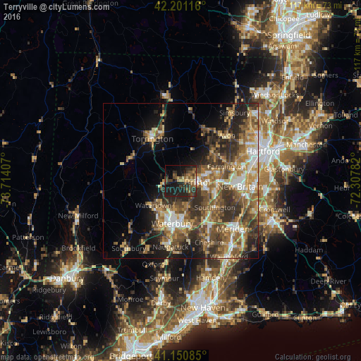
Analysis of Terryville night lights 2016
Square area 10x10 km:
 0.32%
0.32%90-99
0.32%80-89
4.71%70-79
4.55%60-69
3.73%50-59
8.77%40-49
6.82%30-39
10.71%20-29
15.26%10-19
31.49%0-9
13.31%Square area 50x50 km:
3.38%90-99
3.9%80-89
4.21%70-79
5.15%60-69
5.64%50-59
6.78%40-49
6.49%30-39
6.31%20-29
7.98%10-19
9.47%0-9
40.7%Clear (daylight) street map image can be seen on geolist.org.
Map coordinates:
42° 12' 4.2" North, 73° 42' 50.7" West
41° 40' 41.3" North, 73° 0' 39.4" West
41° 9' 3.1" North, 72° 18' 28.2" West
Some cities around Terryville sort by population:
• Waterbury
13.8 km =8.6 mi,  194°
194°
• Bristol
5.2 km =3.2 mi,  97°
97°
• Torrington
16.4 km =10.2 mi,  326°
326°
• Farmington
15.6 km =9.7 mi,  72°
72°
• Plainville
12.7 km =7.9 mi,  91°
91°
• Wolcott
8.7 km =5.4 mi,  166°
166°
• Plymouth
3.5 km =2.2 mi,  258°
258°
• Oakville
11.3 km =7 mi,  213°
213°
4844084 (p: 5,387)
Sources (retrieved 2019-11-25):
» Earth at Night: Flat Maps 2012, 2016