Clayton night lights from space
Night Light of Clayton (California) from space (United States) Src. Average luminocity for 10x10km area is 27.4318% and for 50x50km: 29.0913%.
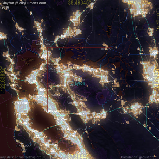
Analysis of Clayton night lights 2016
Square area 10x10 km:
 1.46%
1.46%90-99
1.14%80-89
0.32%70-79
3.25%60-69
4.38%50-59
11.04%40-49
7.14%30-39
3.08%20-29
18.02%10-19
25.65%0-9
24.51%Square area 50x50 km:
4.31%90-99
4.06%80-89
1.52%70-79
3.95%60-69
5.31%50-59
6.66%40-49
5.21%30-39
4.07%20-29
11.15%10-19
16%0-9
37.75%Clear (daylight) street map image can be seen on geolist.org.
Map coordinates:
38° 29' 36.4" North, 122° 38' 20.1" West
37° 56' 27.7" North, 121° 56' 8.8" West
37° 23' 3.9" North, 121° 13' 57.6" West
Some cities around Clayton sort by population:
• Concord
9.3 km =5.8 mi,  296°
296°
• Pittsburg
10.7 km =6.6 mi,  24°
24°
• Walnut Creek
12 km =7.5 mi,  251°
251°
• Pleasant Hill
11 km =6.8 mi,  274°
274°
• Bay Point
10 km =6.2 mi,  346°
346°
• Alamo
13.2 km =8.2 mi,  219°
219°
• Contra Costa Centre
10.8 km =6.7 mi,  262°
262°
• Waldon
10.6 km =6.6 mi, 261°
5337841 (p: 11,867)
Sources (retrieved 2019-11-25):
» Earth at Night: Flat Maps 2012, 2016