Blackhawk night lights from space
Night Light of Blackhawk (California) from space (United States) Src. Average luminocity for 10x10km area is 25.6003% and for 50x50km: 36.4346%.
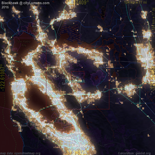
Analysis of Blackhawk night lights 2016
Square area 10x10 km:
 1.36%
1.36%90-99
1.19%80-89
0%70-79
1.36%60-69
4.25%50-59
14.46%40-49
6.97%30-39
3.4%20-29
12.07%10-19
19.39%0-9
35.54%Square area 50x50 km:
6.33%90-99
6.39%80-89
1.76%70-79
4.96%60-69
6.2%50-59
7.75%40-49
6.16%30-39
4.65%20-29
11.83%10-19
17.73%0-9
26.24%Clear (daylight) street map image can be seen on geolist.org.
Map coordinates:
38° 22' 26.7" North, 122° 36' 39.1" West
37° 49' 14.7" North, 121° 54' 27.9" West
37° 15' 47.7" North, 121° 12' 16.6" West
Some cities around Blackhawk sort by population:
• San Ramon
7.7 km =4.8 mi,  233°
233°
• Walnut Creek
16.8 km =10.4 mi,  304°
304°
• Dublin
13.4 km =8.3 mi,  190°
190°
• Danville
8.1 km =5 mi,  270°
270°
• Alamo
11.4 km =7.1 mi,  286°
286°
• Clayton
13.6 km =8.5 mi,  349°
349°
• Waldon
17.5 km =10.9 mi,  312°
312°
• Saranap
16.4 km =10.2 mi, 295°
5329204 (p: 9,354)
Sources (retrieved 2019-11-25):
» Earth at Night: Flat Maps 2012, 2016