Rio Vista night lights from space
Night Light of Rio Vista (California) from space (United States) Src. Average luminocity for 10x10km area is 10.9983% and for 50x50km: 11.2775%.
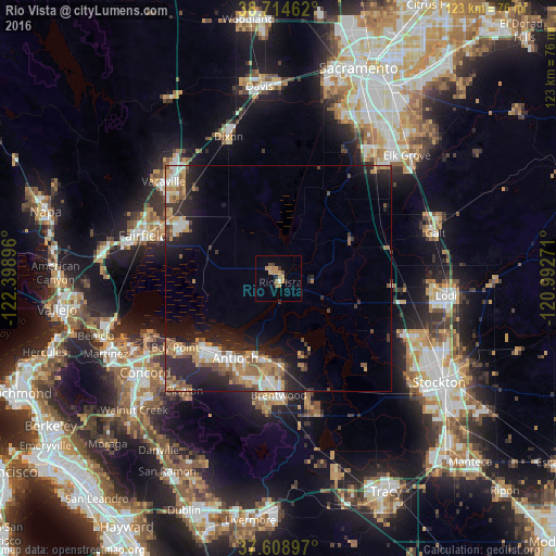
Analysis of Rio Vista night lights 2016
Square area 10x10 km:
 0.51%
0.51%90-99
0.17%80-89
0%70-79
5.61%60-69
3.23%50-59
0.68%40-49
1.36%30-39
1.36%20-29
1.36%10-19
0%0-9
85.71%Square area 50x50 km:
1.54%90-99
1.7%80-89
0.56%70-79
2.2%60-69
2%50-59
1.73%40-49
1.53%30-39
1.39%20-29
4.25%10-19
6.49%0-9
76.6%Clear (daylight) street map image can be seen on geolist.org.
Map coordinates:
38° 42' 52.6" North, 122° 23' 56.3" West
38° 9' 50" North, 121° 41' 45" West
37° 36' 32.3" North, 120° 59' 33.8" West
Some cities around Rio Vista sort by population:
• Fairfield
31.5 km =19.6 mi,  287°
287°
• Antioch
20.1 km =12.5 mi,  208°
208°
• Pittsburg
22.4 km =13.9 mi,  227°
227°
• Brentwood
25.8 km =16 mi,  179°
179°
• Oakley
18.6 km =11.6 mi, 184°
• Suisun
31.2 km =19.4 mi, 285°
• Bay Point
27.7 km =17.2 mi,  237°
237°
• Discovery Bay
29.6 km =18.4 mi,  163°
163°
7536026 (p: 8,348)
Sources (retrieved 2019-11-25):
» Earth at Night: Flat Maps 2012, 2016