Oak Harbor night lights from space
Night Light of Oak Harbor (Washington) from space (United States) Src. Average luminocity for 10x10km area is 19.6146% and for 50x50km: 4.4644%.
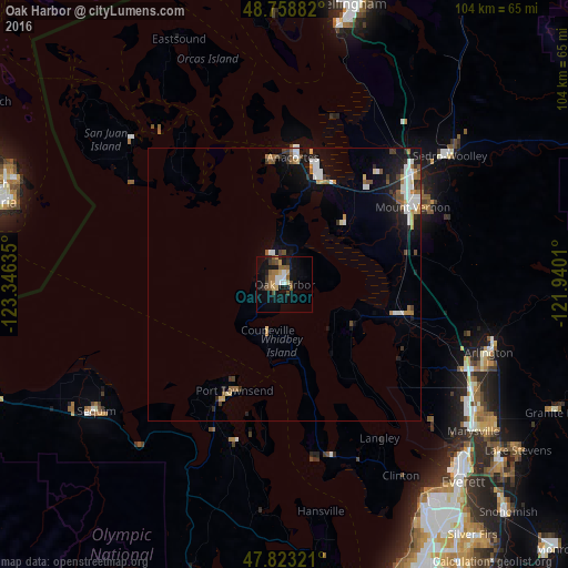

Analysis of Oak Harbor night lights 2016
Square area 10x10 km:
 1.93%
1.93%90-99
2.23%80-89
2.68%70-79
1.79%60-69
3.57%50-59
4.32%40-49
2.98%30-39
1.93%20-29
1.79%10-19
18.15%0-9
58.63%Square area 50x50 km:
0.8%90-99
0.76%80-89
0.39%70-79
0.35%60-69
0.65%50-59
0.61%40-49
0.42%30-39
0.52%20-29
0.74%10-19
3.41%0-9
91.34%Clear (daylight) street map image can be seen on geolist.org.
Map coordinates:
48° 45' 31.8" North, 123° 20' 46.9" West
48° 17' 35.4" North, 122° 38' 35.6" West
47° 49' 23.6" North, 121° 56' 24.4" West
Some cities around Oak Harbor sort by population:
• Mount Vernon
26.9 km =16.7 mi,  58°
58°
• Anacortes
24.5 km =15.2 mi,  5°
5°
• Camano
15.8 km =9.8 mi,  147°
147°
• Sedro-Woolley
38.1 km =23.7 mi,  52°
52°
• Port Townsend
21.4 km =13.3 mi,  203°
203°
• Tulalip
36.1 km =22.4 mi,  133°
133°
• Burlington
31 km =19.3 mi, 49°
• Stanwood
21 km =13 mi,  105°
105°
5805441 (p: 22,693)
Sources (retrieved 2019-11-25):
» Earth at Night: Flat Maps 2012, 2016