Port Townsend night lights from space
Night Light of Port Townsend (Washington) from space (United States) Src. Average luminocity for 10x10km area is 5.7351% and for 50x50km: 1.4484%.
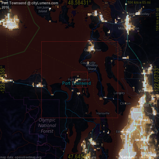
Analysis of Port Townsend night lights 2016
Square area 10x10 km:
 0%
0%90-99
0%80-89
1.19%70-79
1.19%60-69
0.74%50-59
1.64%40-49
0.6%30-39
1.64%20-29
2.53%10-19
0%0-9
90.48%Square area 50x50 km:
0.09%90-99
0.12%80-89
0.17%70-79
0.16%60-69
0.24%50-59
0.3%40-49
0.28%30-39
0.33%20-29
0.28%10-19
0.88%0-9
97.16%Clear (daylight) street map image can be seen on geolist.org.
Map coordinates:
48° 35' 3.5" North, 123° 27' 48.9" West
48° 7' 1.3" North, 122° 45' 37.6" West
47° 38' 43.7" North, 122° 3' 26.4" West
Some cities around Port Townsend sort by population:
• Oak Harbor
21.4 km =13.3 mi,  23°
23°
• Mukilteo
38.9 km =24.2 mi,  119°
119°
• Camano
18.4 km =11.4 mi,  69°
69°
• Poulsbo
43.2 km =26.8 mi,  168°
168°
• Tulalip
35.2 km =21.9 mi,  98°
98°
• Picnic Point
41.5 km =25.8 mi,  129°
129°
• Sequim
25.7 km =16 mi,  260°
260°
• Stanwood
32 km =19.9 mi,  64°
64°
5807239 (p: 9,335)
Sources (retrieved 2019-11-25):
» Earth at Night: Flat Maps 2012, 2016