Tulalip night lights from space
Night Light of Tulalip (Washington) from space (United States) Src. Average luminocity for 10x10km area is 3.304% and for 50x50km: 13.0715%.
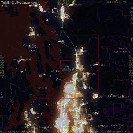
Analysis of Tulalip night lights 2016
Square area 10x10 km:
 0%
0%90-99
0%80-89
0%70-79
0%60-69
0%50-59
1.14%40-49
0%30-39
1.7%20-29
0.57%10-19
6.68%0-9
89.91%Square area 50x50 km:
2.47%90-99
2.63%80-89
1.17%70-79
1.74%60-69
1.63%50-59
1.61%40-49
1.25%30-39
1.89%20-29
4.67%10-19
6.33%0-9
74.61%Clear (daylight) street map image can be seen on geolist.org.
Map coordinates:
48° 32' 10.1" North, 122° 59' 41.8" West
48° 4' 6.3" North, 122° 17' 30.5" West
47° 35' 47.1" North, 121° 35' 19.3" West
Some cities around Tulalip sort by population:
• Everett
12 km =7.5 mi,  146°
146°
• Marysville
8.7 km =5.4 mi,  102°
102°
• Lake Stevens
18 km =11.2 mi,  109°
109°
• Mukilteo
13.8 km =8.6 mi,  183°
183°
• West Lake Stevens
16.4 km =10.2 mi,  120°
120°
• Eastmont
20.7 km =12.9 mi,  156°
156°
• Arlington
19 km =11.8 mi,  40°
40°
• Stanwood
20.1 km =12.5 mi,  343°
343°
5814047 (p: 9,246)
Sources (retrieved 2019-11-25):
» Earth at Night: Flat Maps 2012, 2016