Stanwood night lights from space
Night Light of Stanwood (Washington) from space (United States) Src. Average luminocity for 10x10km area is 4.9301% and for 50x50km: 6.9404%.
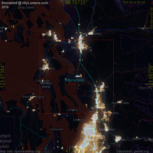
Analysis of Stanwood night lights 2016
Square area 10x10 km:
 0.74%
0.74%90-99
1.04%80-89
0%70-79
0.15%60-69
2.68%50-59
0.15%40-49
0.15%30-39
0.45%20-29
0%10-19
0.6%0-9
94.05%Square area 50x50 km:
0.88%90-99
1.03%80-89
0.62%70-79
0.76%60-69
1.04%50-59
1.17%40-49
0.75%30-39
0.88%20-29
2.44%10-19
5.39%0-9
85.05%Clear (daylight) street map image can be seen on geolist.org.
Map coordinates:
48° 42' 26.5" North, 123° 4' 25.8" West
48° 14' 28.4" North, 122° 22' 14.6" West
47° 46' 14.8" North, 121° 40' 3.3" West
Some cities around Stanwood sort by population:
• Marysville
25.5 km =15.8 mi,  145°
145°
• Mount Vernon
20.2 km =12.6 mi,  7°
7°
• Oak Harbor
21 km =13 mi,  285°
285°
• Arlington
18.8 km =11.7 mi,  104°
104°
• Camano
13.9 km =8.6 mi,  237°
237°
• Sedro-Woolley
30.9 km =19.2 mi,  18°
18°
• Tulalip
20.1 km =12.5 mi,  163°
163°
• Burlington
26.3 km =16.3 mi, 7°
5811995 (p: 6,779)
Sources (retrieved 2019-11-25):
» Earth at Night: Flat Maps 2012, 2016